Wednesday, May 22, 2019

Part 10 - Tanque Verde Falls.


Part 10 - Tanque Verde Falls.


Not sure where to start with this place. In true Arizona fashion, there is so much to do here, that it really is hard to cover it all.

Redington Pass seems like a good starting point since Tanque Verde Falls is just a small part of that larger area. Redington is a passage between the Catalina and Rincon Mountains, containing many miles of off-road trails maintained by the Tucson Rough Riders. So, I would like to start by thanking them for all of their efforts and by linking their web-page below:

Website: Tucson Rough Riders

Here is another link that may be helpful to those planning an off-road trip here.

Website: Rider Planet on Redington Pass

In addition to Off-Highway Vehicle trails, there are several hiking trails that cross through this area as well. The most well known is the Arizona Trail. It passes from Italian Trap, through Redington, and into Molino Basin before ascending the Catalina Mountains. Redington is a huge place and we really haven't explored much of it so far, so lets get on to talking about Tanque Verde Falls where the best Summer activity awaits...Swimming!!!

This drive can be tough for people with a fear of heights, there are no guardrails, and it is narrow when oncoming traffic is present.  Parking for Tanque Verde Falls can be found on Redington Rd.  Shortly after the blacktop turns to dirt, there will be a dirt lot on the left hand side. If you hit the off road vehicle staging area, you have went too far.

Warning: This area is very popular with nudists. In vehicles, on trails, and in the water. You have been warned!!!


The falls can be a very dangerous place during monsoon season, so another warning is due. Please check the weather before hiking into the canyon, as several people have been swept away and killed during flash floods. Read the sign below. Know it. Live it.

Warning sign on the descent from Redington to Tanque Verde Creek.

The trail begins across the road from the parking lot, and the sign above makes for a good landmark, before starting the switchbacks down into the canyon. Once the canyon floor becomes visible, you can get a good indication if the falls will have water or not. This is a good sign:

A view from the descent into the canyon, looking upstream.

Looking down at Tanque Verde Creek from the trail on the ridge above.
Upon reaching the canyon floor, head upstream, or turn left if there is no water. If you are climbing down the canyon instead of climbing up...you are going the wrong way. This is one of our favorite hikes, but the first time we went, the falls were dry. So most of these pictures are from our 2nd and 3rd trip.

Small waterfalls like this one are common when water is present, and they make negotiating the climb a little more challenging. There really isn't a trail in the canyon, its just boulder hopping, which is why we love it so much.
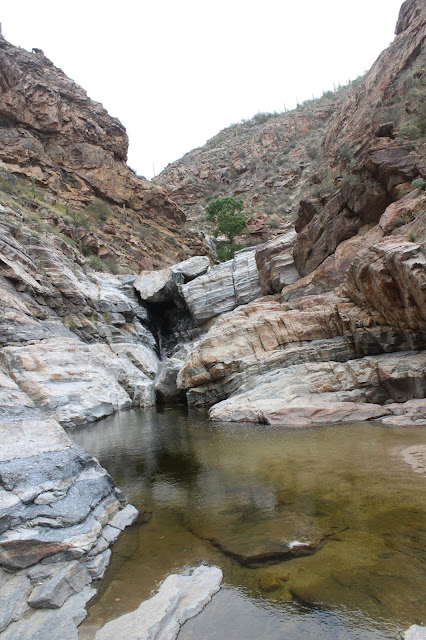

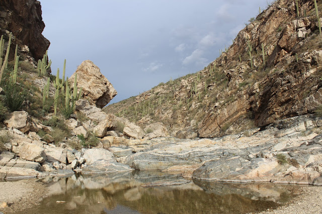
A view of one of the many pools on the climb up the canyon. 

Closer shot of the same pool. 

Our favorite view of the canyon, is looking downstream at 'The Rock'. No, not Dwayne Johnson, this rock: 

'The Rock' A big, square one. Not the wrestler.
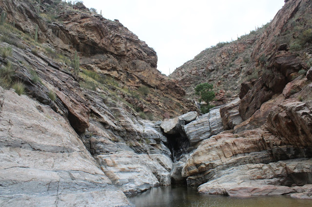
I believe there are about 4 or 5 bends in the canyon before coming to the first set of falls, which is around 30 feet high. This picture was from a dry January day, and as you can see, there are no falls. Normally, the water would flow off the gray stone above, and down to the pool. 

Lower Tanque Verde Falls. No falls, just a pool. 
On our first trip, when the falls were dry, we climbed partially to the top of the 30 foot drop and were stopped on a ledge. We debated climbing up to see the upper falls, but the rest of the climb looked kind of sketchy. We sat down on the ledge and had lunch while we talked about finishing the climb. Still undecided, we stood up to look at handholds again when we noticed something.  We had been sitting next to what looked like several small puddles of dried blood. We decided against finishing the climb, especially since there was a good chance those falls were dry too. On the way out, we ran into someone who asked us if we saw the guy get airlifted out yesterday. Shit! Now we know where that blood came from. Undaunted, we swore we would return to get to see water in both sets of falls. 

Fast forward to March, and we had enough snowmelt/showers to keep the water flowing in the creek, so we knew the falls would be going strong. We boulder hopped our way over the creek, taking shoes off once or twice, and made it back to the base of the first falls. We really did not want to risk that climb where we saw the blood...but now what??? Luckily, we ran into other hikers who showed us a less dangerous climb that bypassed the first set of falls. 

Looking down on this secluded, ecological gem from the trail above was like being in some strange storybook-land. There were the falls, roaring in the distance, with a single tree that managed to root-down through all of the flooding and erosion. There were people here, not many, and none of them naked. Whew. 

Stranger Danger!!!

We explored, relaxed by the water, and took some pictures before leaving. I even got Jen to look at the camera for one. 

Pretty girl on a secluded sandy beach next to a waterfall. I love Arizona!!!

Below: Our video of Lower Tanque Verde Falls.


Below: Our video of Upper Tanque Verde Falls. 


We loved Tanque Verde Falls so much, that we forced our friend who is scared of heights to drive up Redington for a hike with us. I met Ginni through the lab I worked at, she was with the same staffing agency, and was also traveling in an RV with her family. Her husband David, son Micah, and their two doggos (Jake and Bella) went with us.  

Here are some pics from that trip in May of 2018, before we both went on to other assignments. 

Ginni, David, Micah, doggies...and other visitors. 


Ginni and Jenny. Was Jenny standing on a rock or was Ginni crouching?


Such a fun trip. We miss you guys!!!

Micah!


A small waterfall at the very beginning of the hike up to the real falls. 


One more 'Rock' for the road.
If you live in Tucson, love hiking nude, and don't mind embarrassing the Hell out of your self...then this is the place for you. For the rest of us, we really wish you wouldn't ruin a great hiking spot like that...can't you just tan naked in your backyard like a normal person???

Maybe I'm just jealous because I cant even skinny dip at night without getting a sunburn. Guilty of being Irish. Right then! On to the next adventure!!!

Previous Entry:

Part 9B - Mt Wrightson Wilderness Area.

Stay tuned for our next article about our road trip home. It will be posting on Monday June 3rd.


Part 9B - Mt Wrightson Wilderness Area.


Part 9B - Mount Wrightson Wilderness Area. 

Gardner Canyon and Cave of the Bells.

Forest Service Website: Mt Wrightson Wilderness Area

In Advance: Cave of the Bells is gated and locked and the key must be acquired from the Forest Service. Here is a link with all of the important information for Cave of the Bells.

Forest Service Website: Cave of the Bells

Jenny is not vegetarian enough to ignore the attraction of cave bacon.


Warning: Since these are unmaintained fire roads, a high clearance 4x4 vehicle is recommended. 

Maybe I did see a smuggler, but its really none of your business. 

This hike is very close to the border, and signs like the one above are common. Oddly enough, we met a stranded couple whose battery had died, and the husbands work Visa was about to expire. We got them going again and they were on their way to Costa Rica through Mexico. I often wonder what happened to them. 

Gardner Canyon is one of several canyons accessible by fire road from Highway 83. Heading South from Tucson on 83 will take you past Box Canyon Rd (FR 62) and through a border patrol checkpoint before reaching the Gardner Canyon Rd (FR 92) turn off. This area is very dry and grassy, with free range cattle never far from the roadside. 

Free-range cattle along Gardner Canyon Rd in the Santa Rita Mountains of Arizona.

Going farther in on FR 92 took us past the turn-off for Kentucky Camp, an old mining ghost town. Several areas along the roadside are designated off-road campsites and a large parking area served as a boon-docking site for several off-grid travel trailers. Farther still on FR 92 and we passed the Apache Ranch and parking for the Arizona Trail before dropping into a wash at Cave Creek. Just before this wash is a 45 degree angle pull off from the road, which made a nice camping spot for us. I found a small sinkhole nearby that I rapelled into, but the passage did not go very far before pinching off to nothing.

A 20 foot deep sink that I rapelled into to check for leads.


Testing my rigging before jumping in.


So continuing on FR 92 past the Cave Creek Wash, turn right on FR 4084 and go down another wash and up the other side bending around to a junction with FR 4085. Turn Right onto FR 4085 and cross Sawmill Canyon until the road forks left onto FR 4086 which ends shortly at a camping area for Cave of the Bells.

A group shot of Alpha Team Badass, as coined by my friend Jesse Roberts who snapped this picture. This was right before we entered the cave.

Jesse is super happy. This was all his idea. LOL!!!

The gate can be found by following a trail that leads uphill from behind this sign. There is a short climb down that does require either some previous climbing experience or an adventurous soul and a lanky body to give you the wingspan for the climb.

Hello down there.

As mentioned at the beginning of the article, the Forest Service maintains Cave of the Bells. This is a medallion marking the entrance. In typical government style, you will notice they skip the name in favor of a non-descript number.

Certified and approved.


Beyond the gate, lies the entrance tunnel, which must have been tiny to begin with because it was only widened to an opening about 2.5 feet square.

Highway to Hell?


Just past the gate and the squeeze through the tunnel, the room opened up a bit to reveal ceilings that sparkled with some sort of microorganism.

Microbes?


In this room, near the exit, is a standard cave register tube that contains a check-in list.

Obligatory PVC cave register.

Alpha Team Bad Ass!!!

The large entrance room sloped down on one end to a slick climb down to an attached room that was adorned with pits. Several of these had long drops to who knows where...except one. The one just to the right,when sliding down the entry slope, was only about 8 feet deep and looked promising. Climbing down that sinkhole seemed to go nowhere until turning around brought the revelation that you could effectively crawl under the pit room you just climbed down from. Caves are so uniquely fun and confusing at the same time.

We're in a tight spot. 

A few small formations were seen along the way, but nothing too cool yet.

Cave popcorn


Legend says the cave got its name from the sound the cave formations would make, when struck with a hammer. Of course, we know better than that now, and the only thing getting struck with a hammer is the person suggesting to hit speleothems.

This was what I believe is the Bell's room and it had the coolest piece of cave bacon I had ever seen.

Jenny is not vegetarian enough to ignore the attraction of cave bacon.

An enormous piece of flow-stone.
There were many options to continue going, but those would have to wait. It was time to turn around and head for the surface. This is a great cave, with little to no bat population, so I was told that White Nose Syndrome (WNS) is not a concern.

Link to information on White Nose Syndrome in bats.

I still recommend sterilizing your gear before entering unless your equipment has never left Southern Arizona caves. Here is a direct link to the decontamination process.

Gear decontamination process for White Nose Syndrome.

 Another piece of advice for cavers not from the area...Southern Arizona caves run hot...like in the mid 70 degree range. So don't overdress like I did, its part of the reason I cut the trip short.

Lastly: I'm still amazed that this cave is not regulated more since it is definitely not a beginners cave. Please seek out qualified leadership before entering from either the Forest Service or reach out to someone from a local grotto of the National Speleological Society. Link below.

Homepage for the National Speleological Society

If you have any interest in caves, please go and visit the NSS website where you can join up and find information on safety and conservation. Who knows, maybe you could meet new friends to cave with like we did. Have fun and always respect the 'leave no trace principles'. See ya next time.

Previous Entry:

Part 9A - Mt Wrightson Wilderness Area

Following Entry:

Part 10 - Tanque Verde Falls.


Tuesday, May 21, 2019

Part 9A - Mt Wrightson Wilderness Area


Part 9A: Mount Wrightson Wilderness Area.

Old Baldy Trail to Wrightson Peak. 

Forest Service Website: Mt Wrightson Wilderness Area


Sign marking the peak on Mt Wrightson.

This place literally has something for everyone.  Hiking, Spelunking, Off-Road Vehicle Trails, Picnic Areas, Bird Watching, Historic and Active Mining Sites, as well as Bed and Breakfast locations all can be found inside the boundaries of this 25,260 acre wilderness area. 

Mt Wrightson, also known as Old Baldy, is the highest peak in the Tucson area. We could see it very clearly from Cactus Country RV Park and we were determined to make it to the top of the 9,456 foot peak before our time in Tucson came to an end. So, on an early Spring morning, we drove up Madera Canyon and parked at the bottom of the Old Baldy Trail to begin our hike. We had gotten a later start than we wanted to and were pretty sure we didn't have time to get back to the vehicle before dark.  From the parking area, 6.6 miles of trail climbs 3,986 feet to the summit of Mount Wrightson. The entire trip took us around 7-8 hours at a leisurely hike that included a lunch-break.

The best thing about the Old Baldy Trail is that it is tolerable, even during the hot Summer months, thanks to the shade trees that cover most of the lower elevations. Here is a view of the peak from a vantage point, shortly after starting our ascent from the parking lot.


Old Baldy, so called due to the peaks location above the treeline. 

The trail begins to climb right away and does not really level off until reaching Josephine Saddle about 2.2 miles up the hike. There was a freak snowstorm that blew in here and took the lives of several young Boy Scouts, so even this far South, the mountains demand that you prepare for any kind of weather. Here is a great story about the incident, with a recent update, that makes the ending a little happier:  Tucson.com Josephine Saddle Article

We did not take any pictures of the memorial crosses at the saddle, and continued on up to where the Super Trail intersects with the Old Baldy Trail. Taking this route kept us on the West side of the peak, saved us a few miles, and kept us away from the fire ravaged area on the East side.

The hike up from the Super Trail split is very scenic, but the tree cover starts to thin out here, especially near some exposed areas where the trail skirts a cliff edge.  We found a good view of the peak near one of these cliff edges and sat down for a packed lunch.


Getting closer. View from our lunch spot below the peak. 

There are seasonal springs below Old Baldy Saddle and this part of the trail requires a little bit of boulder hopping. Just above this area, the trail begins a brutal series of switchbacks (around 30), before reaching a very windy Baldy Saddle.


A view to the East from Baldy Saddle. 


Fire damage on the Eastern slopes of the Santa Ritas.

There are no words that can describe the feeling of pushing yourself to do a hike like this, and this was by far the toughest one of our lives. After leaving Baldy Saddle, the trail climbs almost one mile up to Old Baldy Peak. However, it was scrambles over rock face, some exposed edges on the trail, and switchbacks where you could see the stacked stone for the next switchback as you climbed up.

Sketchy trail with a very exposed edge near the Old Baldy summit.


Jenny on the crest trail about halfway to the peak.
Facing South on the last switchback before the peak. 

As you can see from those pictures, the views near the top were amazing, and it was worth every struggling step to get there.  At the top, was a marker designating the peak as part of the Coronado National Forest and showing pictures of the old fire lookout that used to call the peak home.

Looking West from the peak. Upper Left: The road to the Mt Hopkins Observatory can be seen. 


Looking SW from the peak. Road to Mt Hopkins on the right. 

We did it!
Jen standing on whats left of the base of the old fire tower. 

Me trying to stay warm and not get blown off the mountain.
We took a very short video from the peak. It begins facing East and then pans South where you can see into Mexico. 


In total, we probably spent about 5 to 10 minutes at the summit. The wind was icy and piercing, so we just took a few pictures/video, admired the view, and started down. The exposed areas on the crest trail were a little more intimidating on the descent, but the 30 some switchbacks below Baldy Saddle were much easier. It got dark on us just before we reached Josephine Saddle and we had to use our headlamps for the rest of the trek out. I think the whole trip took us about 10 hours in total and we were a little sore the next day, but ready for the next adventure. 

Here is a link to our last article about moving to the SE side of town.

Part 8 - Cactus Country

Here is a link to the follow-up article.

Part 9B - Mt Wrightson Wilderness Area

Friday, May 3, 2019

Part 8 - Cactus Country.


Part 8 - Cactus Country.

10195 S Houghton Rd
Tucson, Arizona. 85747.
520-574-3000

Website: Cactus Country RV Park.

We moved our RV to the East Side of Tucson and spent the rest of the winter at Cactus Country RV Resort.

Cactus Country entryway. 

The spaces were decent size and equal proportion. The facilities were well kept and the staff was friendly and helpful. Best of all, they had a large dog run area with a toy bin and picnic tables.

Bugzy loved the dog run. Every time we walked by it, he would pull us over to the gate wanting in. 

Bugzy and Luna in the dog run. It was more than enough room for them to get exercise.
Luna. Perched on a picnic table. 

Luna likes picnic tables. 


We met great people there, and if anything, our dogs were the troublemakers.

Aside from our neighbors who never spoke to us, we loved our site.  We had plenty of room to park the truck, put the camper awning out, and we even had a small cactus garden.


Cactus Country RV. Site 142
TV at night. Can't do this in Illinois, unless you are wearing a bug-net. 

Our cactus garden and outdoor area was nice, but our favorite part was spending the winter somewhere with a really nice pool and hot tub area!

Pool and hot tub at Cactus Country. 

Another shot of the pool area. 

Pros:  The heated swimming pool and hot tub were our favorite part of the park, but the location was a plus too.  Our last RV park was a 20 to 30 minute drive to a grocery store, now we had a short drive up Houghton to get to both a Walmart and a Fry's Foods. 

The bathrooms were clean, the showers were in need of repair, but they were set for repairs when our stay ended. The laundry room was nice and spacious and coins were available in the office. We were also happily surprised to see clotheslines, which saved us a lot of money. Clothes dry fast down here, unfortunately most RV parks treat clotheslines as an eyesore and a nuisance, but not Cactus Country. 

Our laundry on the line with our trusty red wagon off on the left.

A very nice pavilion with picnic tables is located on the edge of the park and used for community gatherings. I used it to host a cookout for some of my work-friends before we all parted ways. The rec-room had two pool tables, a book exchange, and a piano (which I played frequently). In summary, the facilities were on par with Desert Trails, but the fact that we felt respected and welcomed won us over on Cactus Country.

Our picnic pavilion at Cactus Country

Giant Lantana bush with flowers in the foreground. Blooming ocotillo on back right. 

Cons:  The biggest drawback of this place, as well as most RV parks in the area, is that it is a 55+. park. What that means is that if you are under 55 you have to get permission to stay here and they are pretty strict on not letting anyone with children camp here. So be warned.

Also, the trails leaving the park were nothing compared to  our stay at Desert Trails (See previous blog entry) The trails were so rough and rutted they made biking on them almost impossible. There were no saguaro cacti on the surrounding property, which made the scenery less attractive. We found out that the practice of cattle herding had decimated the population of saguaros here. It was not uncommon to have free range cattle blocking the entrance road, and I was late for work one time due to a cattle crossing.

This was taken from the road into the RV park. Free range cattle. 

In the end, Cactus Country was the best park that we found in town, or the surrounding area. The landscaping and facilities, along with the friendly management, will keep us coming back to this park any time we are in the Tucson area.

Link to our previous article:

Part 7 - Sabino Canyon

Link to our next article:

Part 9A - Mt Wrightson Wilderness Area.